The Ocean Biology Processing Group (OBPG) intiated a full-mission ocean color reprocessing of the NOAA20/JPSS1 Visible and Infrared Imager/Radiometer Suite (VIIRS) dataset in October 2022. This reprocessing is part of a multi-mission effort to update the instrument calibrations, vicarious calibration, and product and algorithm changes. Sensor-independent changes are detailed in the R2022.0 Ocean Color Reprocessing General Description. Here we describe the VIIRS-NOAA20 sensor-specific details of the reprocessing, and provide an assessment of data quality and impact.
The VIIRS Level-1 code has been updated to version 3.2 (which includes support for the upcoming VIIRS on JPSS-2). This change introduces modifications to the geolocation processing code. While the impact of this change is minimal on the geolocation product, we have regenerated the mission archive of these data.
The Level-1A files are identical, except for a product name change to use the new file naming convention.
In this reprocessing, the instrument calibration was updated for the VIIRS instrument to utilize the additional on-board (solar/lunar) calibration measurements collected since the R2018.0 reprocessings, and to incorporate advancements in modeling of sensor radiometric degradation from the on-board calibrators.
The updates for the on-orbit calibration for VIIRS include:
Some changes in products and algorithms have been made for all the missions including VIIRS in this reprocessing, including: chlorophyll, particulate inorganic carbon (PIC), raman scattering, absorption and backscattering spectra for water, ancillary data sources (for ozone, sea surface temperature, land/water mask and bathymetery), multi-scattering Epsilon aerosol model and optical properties determination.,
The straylight flag for VIIRS is a simple dilation of the CLDICE and HILT flags. For VIIRS, a 3x3 kernel is used following the recommendation of Hu et al. (2019) (3 pixesl by 3 lines centered on the flagged pixel).
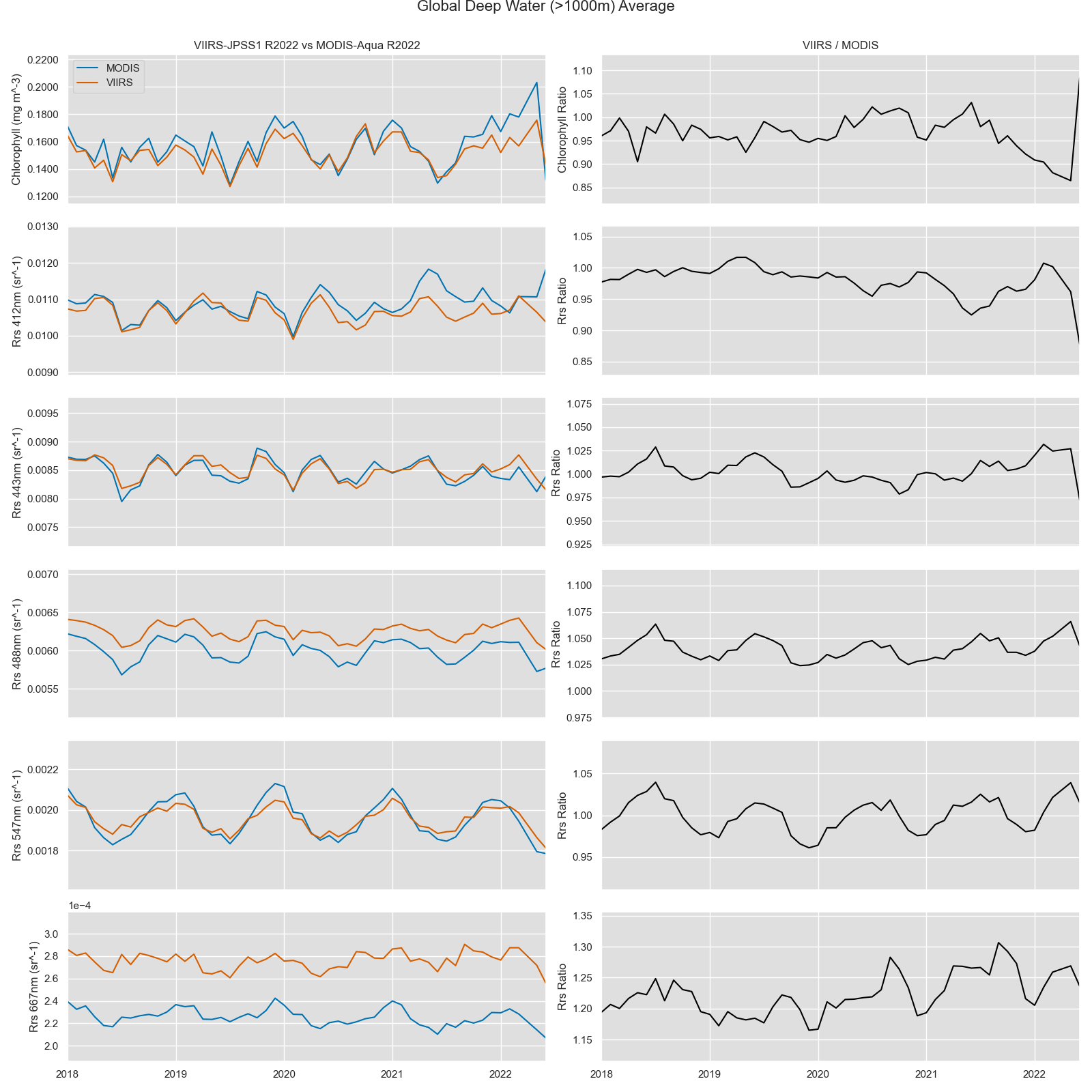
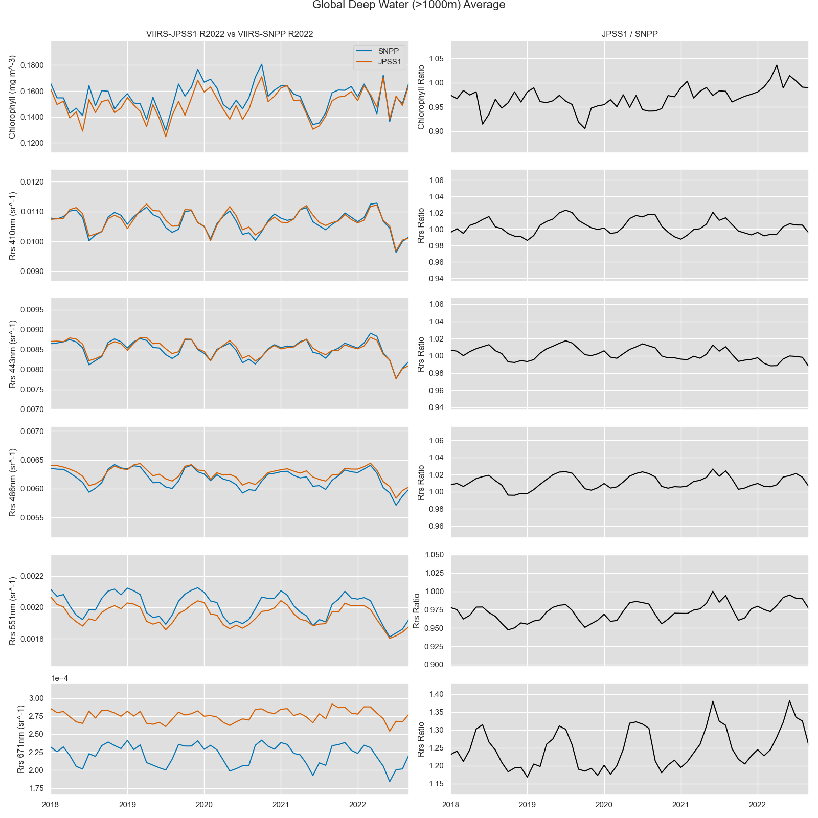
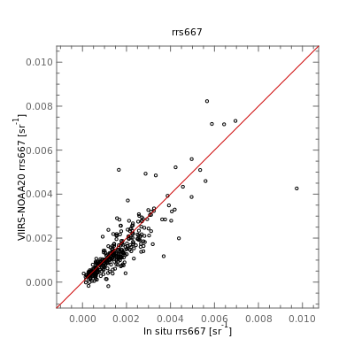
To assess the impact of this R2022.0 reprocessing on VIIRS-NOAA20 relative to MODIS-Aqua and VIIRS-SNPP, a comparative timeseries analysis was perfomed. The impact of all calibration, product and algorithm, and ancillary data changes on chlorophyll and remote sensing reflectance of global deep water (>1000m) is shown in Fig. 1&2. Overall, the Chlorophyll and remote sensing reflectance from VIIRS-NOAA20, MODIS-Aqua and VIIRS-SNPP are identical with a difference within 10%. However, a 20% difference were noticed between Rrs(667) of VIIRS-NOAA20 and SNPP Rrs(671), and 16% for Rrs(667) between NOAA20 and Aqua.
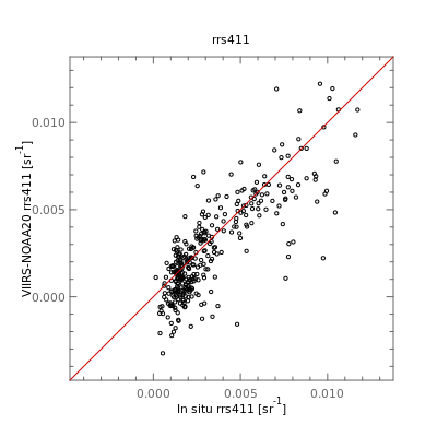
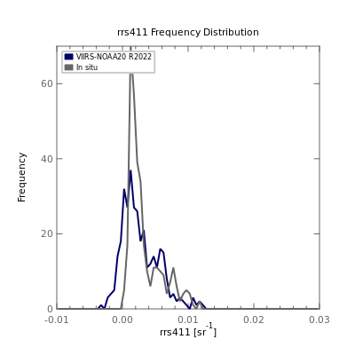
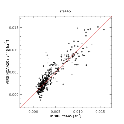
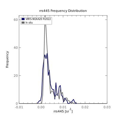
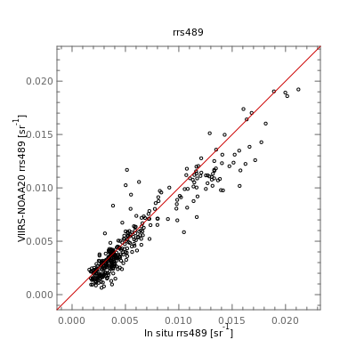
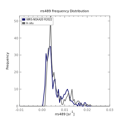
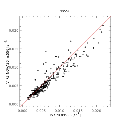
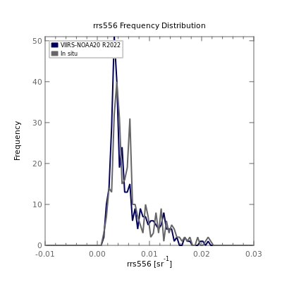
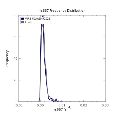
Validation of remote sensing reflectance (Rrs) was performed relative to all available match-ups from SeaBASS and the Aerosol Robotic Network - Ocean Color (AERONET-OC). Statistical analysis, scatter plots and frequency distribution comparisons of the satellite to in situ match-ups are provided below.
| Product Name | # | Mean Bias | Mean Absolute Error (MAE) | VIIRS-NOAA20 Range | In situ Range |
|---|---|---|---|---|---|
| Rrs411 | 342 | -0.00059 | 0.00127 | -0.00324, 0.01223 | 0.00014, 0.01172 |
| Rrs445 | 342 | 0.00016 | 0.00102 | -0.00131, 0.01512 | 0.00065, 0.01583 |
| Rrs489 | 342 | -0.00055 | 0.00101 | 0.00064, 0.01922 | 0.00161, 0.02121 |
| Rrs556 | 333 | -0.00058 | 0.00101 | 0.00128, 0.02130 | 0.00134, 0.02182 |
| Rrs667 | 342 | -0.00017 | 0.00041 | -0.00018, 0.00823 | 0.00005, 0.00974 |
Ahmad, Ziauddin, Bryan A. Franz, Charles R. McClain, Ewa J. Kwiatkowska, Jeremy Werdell, Eric P. Shettle, and Brent N. Holben. 2010. “New Aerosol Models for the Retrieval of Aerosol Optical Thickness and Normalized Water-Leaving Radiances from the SeaWiFS and MODIS Sensors over Coastal Regions and Open Oceans.” Applied Optics 49 (29): 5545. https://doi.org/10.1364/AO.49.005545.
Ahmad, Ziauddin, and Bryan A. Franz (2018), Uncertainty in aerosol model characterization and its impact on ocean color retrievals, in PACE Technical Report Series, Volume 6: Data Product Requirements and Error Budgets (NASA/TM-2018 – 2018-219027/ Vol. 6), edited by I. Cetinić, C. R. McClain and P. J. Werdell, NASA Goddard Space Flight Space Center Greenbelt, MD.
Balch, W. M., et al. (2005). "Calcium carbonate budgets in the surface global ocean based on MODIS data." Journal of Geophysical Research Oceans 110(C7): C07001, doi:07010.01029/02004JC002560.
GEBCO Compilation Group (2020) GEBCO 2020 Grid (doi:10.5285/a29c5465-b138-234d-e053-6c86abc040b9)
Gordon, H. R., et al. (2001). "Retrieval of coccolithophore calcite concentration from SeaWiFS imagery." Geochemical Research Letters 28(8): 1587-1590.
Hu, C., Feng, L., Lee, Z., Franz, B. A., Bailey, S. W., Werdell, P. J., & Proctor, C. W. (2019). Improving satellite global chlorophyll a data products through algorithm refinement and data recovery. Journal of Geophysical Research: Oceans, 124.
McKinna, L.I.W., Werdell, P.J. and C.W. Proctor. 2016. "Implementation of an analytical Raman scattering correction for satellite ocean-color processing." Optics Express, 24(14), A1123-A1137, doi: 10.1364/OE.24.0A1123
O'Reilly, J.E., and Werdell, P. J. (2019). Chlorophyll algorithms for ocean color sensors - OC4, OC5 & OC6, Remote Sensing of Environment 229: 32-47, https://doi.org/10.1016/j.rse.2019.04.021.
Voss, K. J., & Flora, S. (2017). Spectral dependence of the seawater-air radiance transmission coefficient. Journal of Atmospheric and Oceanic Technology, 34(6), 1203-1205. https://doi.org/10.1175/JTECH-D-17-0040.1
Westberry et al. (2013) Influence if Raman scattering on ocean color inversion models, Applied Optics, 52(22), 5552-5561, https://doi.org/10.1364/AO.52.005552
Zibordi, G., Voss, K. J., Johnson, B. C., & Mueller, J. L. (2019). Protocols for Satellite Ocean Colour Data Validation: In Situ Optical Radiometry. IOCCG Ocean Optics and Biogeochemistry Protocols for Satellite Ocean Colour Sensor Validation, Volume 3.0, IOCCG, Dartmouth, NS, Canada. http://dx.doi.org/10.25607/OBP-691
