MODIS Band-Subsetted Level 1A
For details of the MODIS Level-1A file and format, see:
Band-subsetted Level-1A files are modified such that excess bands and data that are not utilized by Oceans are removed.
The resulting Level 1A files are smaller in size and easier to work with:
- A standard MODIS Level-1A product is 575MB (about 220MB compressed), while the reduced Level-1A is 215MB (about 50MB compressed).
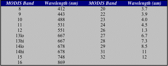
The reduced Oceans level 1A file format retains the following band information:
The Level 1A subsetting allows the Ocean Biology Processing Group to archive and distribute the entire mission online, while still retaining the information needed in the Level 1A subset to derive all higher-level MODIS Aqua Ocean products as well as
true color imagery.
In summary:
- Bands not used for Ocean processing (the 250-meter and 500-meter band Science Data Sets) are removed
- The 1-km bands not listed in table above are zeroed-out to enhance compressibility
- The pixels that saturate are extended with data from similar bands that don't saturate:
(This extended data allows us to create reasonable true color (RGB) images from the 1km data)
- Band 10 is extended using information from band 3
- Band 12 is extended with information from band 4
- Band 13 is extended using information from band 1 and band 16 using information from band 2
Differences between Standard L1A and OBPG subsetted/rescaled L1A
The SDS's that we remove:
- SD_250m
- SD_500m
- SRCA_250m
- SRCA_500m
- BB_250m
- BB_500m
- SV_250m
- SV_500m
- EV_250m
- EV_500m
We modify EV_1km_day:
- Masking Unneeded Day Bands (Fill with -1)
- 17
- 18
- 19
- Rescale saturated 1km R pixels (B13) using 250m R pixels (B1)
- Rescale saturated 1km G pixels (B12) using 500m G pixels (B4)
- Rescale saturated 1km B pixels (B10) using 500m B pixels (B3)
- Rescale saturated 1km IR pixels (B16) using 250m IR pixels (B2)
We modify EV_1km_night:
- Masking Unneeded Night Bands (Fill with -1)
- 21
- 24
- 30
- 33
- 34
- 35
- 36
We add new metadata:
- :B_13_scale_parm = -2664.2217f, 22.313305f ;
- :B_12_scale_parm = -646.60236f, 8.1083326f ;
- :B_10_scale_parm = -564.80042f, 5.699563f ;
- :B_16_scale_parm = -1522.5587f, 14.25313f ;
We alter Aggr fields:
- EV_250_Aggr1km_RefSB:Rescaled Ocean R = 13 ;
- EV_250_Aggr1km_RefSB:Rescaled Ocean NIR = 16 ;
- EV_500_Aggr1km_RefSB:Rescaled Ocean B = 10 ;
- EV_500_Aggr1km_RefSB:Rescaled Ocean G = 12 ;
