7: Putting it all Together
![]()
7: Putting it all Together
![]()
We are facing a very exciting period in Earth Sciences. For the first time in history, we are able to actually measure many of the Earth's 'vital signs', and just like a doctor measures our vital signs to see how healthy we are, scientists will use these measurements of the Earth to better understand how the Earth functions, how the different systems on Earth interact and how those interactions have set the stage upon which life flourishes.
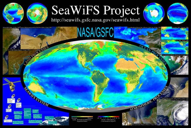
This SeaWiFS image of our world depicts the Global Biosphere - the ocean's long-term average phytoplankton chlorophyll concentration acquired between September 1997 and August 2000 combined with the SeaWiFS-derived Normalized Difference Vegetation Index over land.

This image shows where there is more or less plant life on our planet. On land, the dark greens show where there is abundant vegetation and tans show relatively sparse plant cover. In the oceans, red, yellow, and green pixels show dense phytoplankton blooms, those regions of the ocean that are the most productive over time, while blues and purples show where there is very little of the microscopic marine plants called phytoplankton.
While many planets display similar physical, chemical and geological processes as found here on Earth, there are no other planets that we know about, as yet, where the combination of processes has resulted in life. This image is a representation of that... our living planet.
There is no question that the Earth is changing. Data sets, like this one from SeaWiFS enables us for the first time to monitor the biological consequences of that change - to see how the things we do, and how natural variability, affect the Earth's ability to support life.
The SeaWiFS Poster Teaching Supplement that will be released during the week of October 9, 2000, is designed to augment the remote sensing images of the Earth displayed on the SeaWiFS Project Poster with explanatory text that allows teachers to integrate the images into earth science and environmental science classes. The text describing each image is sufficient to provide a basic understanding of the phenomena that are visible in each image. Supplemental Web links (URLs) are provided to enable the acquisition of additional information or to allow students to participate in independent, investigative learning experiences. A pedagogical section provides additional ideas for teachers to utilize the poster and supplement in the classroom.
The Goddard Earth Sciences DAAC will have the supplement available online as a PDF document, and the URLs found in the supplement will be active links, periodically updated, so that students and teachers can find this information readily. Posters and printed copies of the supplement are available by E-mail request. The supplement can be found in the Educational Resources section of the DAAC's Ocean Color Web site,
![]()
Go to Page:
![]()