Orbview-2 data provided by Fred Patt
In early July 2010 after careful planning and testing of procedures and close consultation with the folks here in NASA's Ocean Biology Processing Group, the folks at GeoEye fired the thrusters on the OrbView-2 (also known as SeaStar) spacecraft over the course of several days to put it into an orbit better suited for the continuing mission of its primary sensor, SeaWiFS.
The orbit had been decaying ever more rapidly which was sending SeaWiFS, which measures reflected visible solar radiation, further and further into the afternoon. In a few more years the Earth under SeaWiFS would have been too dark for the mission to continue.
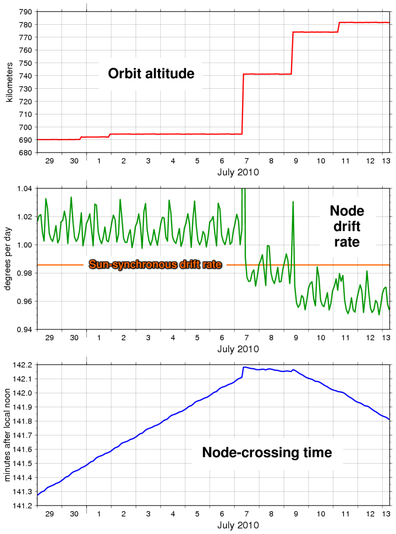
The three plots below show the effects of the thruster firings on the spacecraft. The first plot shows that the spacecraft was raised to a new altitude of 781.5 kilometers above sea level. Combined with a change in the orbit's inclination, this has changed the precession of the spacecraft's orbit to gradually start to move it back towards mid-day as it crosses the equator (i.e. the orbit node). The second plot shows the change in the node drift rate caused by the thruster firings. Since the rate is now less than that required for the spacecraft to always cross the equator at the same local time of day (the sun-synchronous rate), the spacraft will gradually move back toward a mid-day node crossing. The third plot shows the measured change in OrbView-2's node crossing time over several days. The reversal of the drift into the afternoon is clear.
Orbview-2 data provided by Fred Patt
The first SeaWiFS data downlinked after the spacecraft's orbit was corrected show the effects of the change. These six orbit swaths, collected on July 12th and 13th, 2010, are shown below. Because the sensor views the Earth from a higher altitude than it did just a few weeks ago, each scan of its telescope sees a wider portion of the Earth's surface. To highlight the change, the significantly narrower widths of corresponding swaths collected on June 23 and 24, 2010 (before the orbit raising) are marked in green.
If you look carefully, you will also notice that as you move from east to west, each subsequent orbit swath is shifted slightly farther west than the previous one with repect to the earlier June swaths. This is also because the spacecraft is now farther away from the planet and therefore takes longer to complete each orbit than before. This increased orbital period leaves nearly an extra two minutes for the spacecraft to return to the same latitude as the previous orbit during which time the Earth rotates through nearly an extra half degree of longitude.
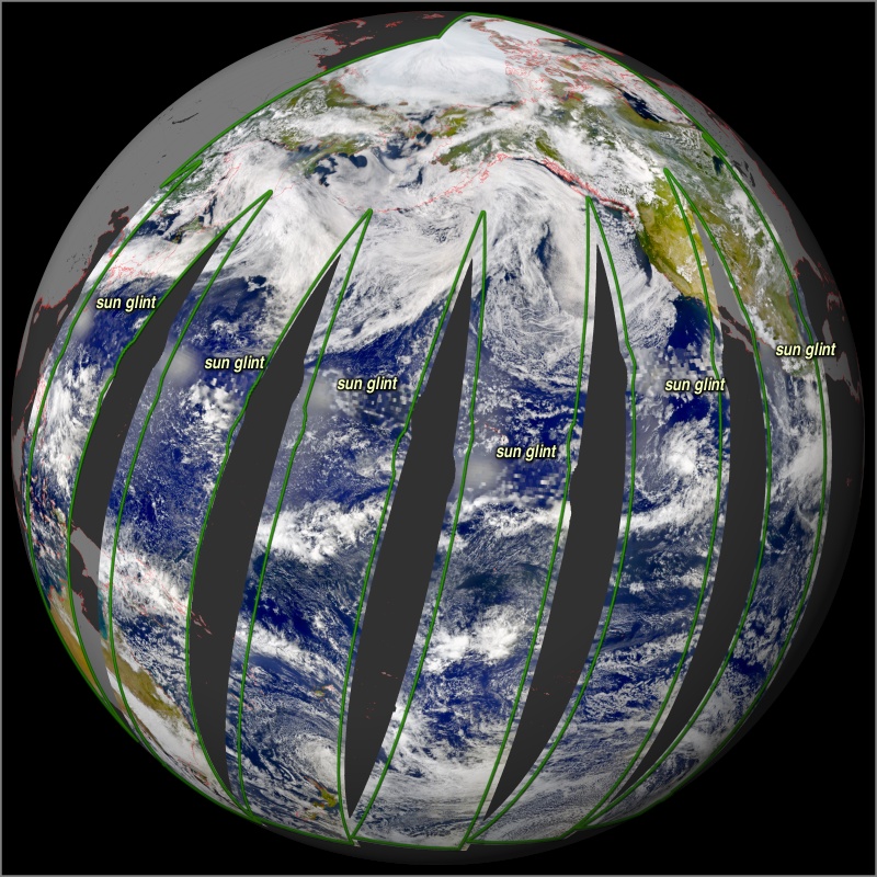
One other feature to notice are the positions of the bright sun-glint regions toward the western edge of each swath. These glint regions will gradually migrate back toward the middle of the swaths over the next few years as SeaWiFS sees the earth closer and closer to local noon.
Hopefully, SeaWiFS will continue to operate for several more years and continue to extend our knowledge of this ocean planet that we live on.