![]()
gene carl feldman (301) 286-9428
Subtle changes in ocean color signify various types and quantities of marine phytoplankton (microscopic marine plants), the knowledge of which has both scientific and practical applications. It became apparent to the oceanographic community that because of the dynamic nature of the world's oceans and climate, and the importance of the ocean's role in global change, a follow-on sensor to the Coastal Zone Color Scanner (CZCS) should be flown. From a scientific perspective, obtaining ocean color data from space in the early 1990s is a high priority goal that has been recognized in reports of the National Research Council of the National Academy of Sciences.
The SeaWiFS Project was designated to develop and operate a research data systemto gather, process, archive, and distribute data received from an ocean color sensor. The principal objective has been to acquire data that are critical for the study of the role of oceans, including the exchange of critical elements andgases between the atmosphere and ocean, and how these exchanges affect phytoplankton production.
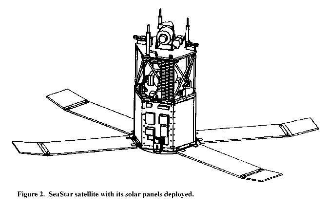
The data was procured as a "data buy" from a private contractor, Orbital Sciences Corporation (OSC), which subcontracted with the Hughes Santa Barbara Research Center (SBRC) to build the SeaWiFS ocean color sensor (Figure 1). OSC built and launched the SeaStar satellite ((Figure 2), carrying the sensor on August 1, 1997. Following launch, the satellite's name was changed to OrbView-2(OV-2), and operations was turned over to ORBIMAGE, a spinoff of OCS.
Program Objectives
The purpose of SeaWiFS data is to examine oceanic factors that affect global change and to assess the oceans' role in the global carbon cycle, as well as other biogeochemical cycles, through a comprehensive research program.
SeaWiFS data are being used to help clarify the magnitude and variability of chlorophyll and primary production by marine phytoplankton, and to determine thedistribution and timing of spring blooms, i.e., the time of highly abundant growth. The scientific and technical experience gained in the SeaWiFS mission have been valuable preparation for the design and application of the Earth Observing System's MODerate resolution Imaging Spectroradiometer (MODIS) instruments, as well as future sensors such as the National Polar-orbiting Operational Environmental Satellite System (NPOESS) Visible/Infrared Imager/Radiometer Suite (VIIRS).
Project Objectives
The purpose of the SeaWiFS Project has been to obtain accurate ocean color data from the world's oceans for a 5-year (minimum) period; to process these data in conjunction with ancillary data into meaningful biological parameters, such as photosynthesis rates; and to make these data readily available to researchers. Goddard Space Flight Center (GSFC) developed the data processing and archiving system and oversaw the effort to ensure the integrity of the final products.
Project Overview
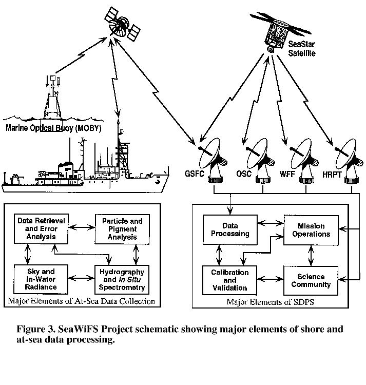
The success of the SeaWiFS mission is determined by the quality of the ocean color data and their availability. Inherent in any space flight mission for scientific applications are Project elements that assure this success. Figure 3 shows the SeaWiFS Project elements within an end-to-end system overview. The OV-2 satellite broadcasts SeaWiFS data in real time to the GSFC High-Resolution Picture Transmission (HRPT) station, as well as to other stations, and recorded data--Global Area Coverage (GAC) and Local Area Coverage (LAC)--to GSFC, WallopsFlight Facility (WFF), and ORBIMAGE. These HRPT, GAC, and LAC data are then transferred to the SeaWiFS Data Processing System (SDPS). The SDPS comprises a number of elements: namely, SeaWiFS data processing; calibration, validation, and data quality; data capture; and GSFC mission operations.
The data processing element receives raw spacecraft data and generates standard global ocean color data products. The standard products go to the GSFC EOS Dataand Information System (EOSDIS) Distributed Active Archive Center (DAAC) which is responsible for archiving and distributing SeaWiFS data to the scientific community.
The calibration and validation element is responsible for establishing and updating calibration procedures for SeaWiFS data, using correlative data for validating higher-level products; analyzing trends and deviations; and collecting ancillary data sets such as winds, ozone, and atmospheric pressure that are used in data processing.
The mission planning element serves as the link between ORBIMAGE and the SeaWiFSProject Office (SPO) for the purposes of reporting problems, monitoring the automatic data measurements and transmission (telemetry), and scheduling the scientific aspects of mission operations. It also provides navigation information and the orbital elements required for data processing and data collection. ORBIMAGE is responsible for the space segment, mission management, and the command and data acquisition station.
Data Calibration, Processing, and Validation
The data calibration, processing, and validation program calibrates the SeaWiFS data; develops the mathematical procedures (algorithms) for operational atmospheric correction and for derived data; and validates the accuracy of the derived products, such as the concentration of chlorophyll a. The atmospheric correction is critical because only about 5% of the light seen at the satellite is reflected from within the ocean (water-leaving radiances). NASA and the SPO have placed the highest priority on assuring the accuracy of calculated water-leaving radiances, globally, over the life of the mission. Although meeting these requirements is an ongoing process, the accuracy and stability of the radiances has been well established, and development of global and regional biogeochemical algorithms has proceeded on many fronts. Some of this work has been done at GSFC, while the remainder has been done externally, by members of the ocean science community.
Included in the processing program has been the development of atmospheric correction and biooptical algorithms required to produce the derived products. The atmospheric correction algorithms for processing SeaWiFS data include a number of improvements over the CZCS algorithms. Data sets from field studies have been collected to validate these improvements.
The field studies mentioned above have been external activities. Internal activities included the development of biooptical databases and the comparison of atmospheric correction and biooptical algorithms. Investigators funded by NASA to assist with algorithm development have had access to these databases.
Atmospheric correction algorithms use external data such as ozone concentrationsand surface pressure fields. The quality of these fields has been assessed before the data were incorporated into the processing. Finally, prior to the release of the derived products, quality assessment and control functions have been performed by comparison of historical and simultaneous field observations submitted to the SPO by field programs and individual investigators.
Data Collection
SeaWiFS has produced scientific data of two spatial resolutions: LAC have been broadcast continuously and recorded selectively, while GAC have been recorded continuously onboard the spacecraft. GSFC has received LAC direct broadcasts routinely for the east coast of the U.S., and various HRPT stations around the world have received other real-time LAC broadcasts. The NASA WFF has received recorded GAC and LAC data, which it has forwarded to the SDPS at GSFC.
In order to meet the science goals, the SPO objectives have been to obtain full GAC data every two days, which has required nearly complete use of onboard recording capability and transmission time to GSFC. The limited space for LAC recording has been allocated, in priority order, to 1) monitoring essential sensor functions; 2) covering key optical calibration and validation activities;and 3) science studies which require full-resolution data.
Data Distribution Policy
The SeaWiFS mission has been made affordable and timely because of its unique private vendor, data purchase structure. As part of the contract between NASA and OSC, NASA retains all rights to data for research purposes, and ORBIMAGE retains all rights for commercial and operational purposes. There has been an embargo period of 2 weeks from collection for general distribution of data to research users to protect ORBIMAGE's commercial interest. Three exceptions to the 2-week embargo are a) field experiments requiring data for ship positioning,b) operational demonstrations to prove feasibility and usefulness, and c) assessment of calibration/validation and instrument performance by NASA. Accessto the NASA data archive has been permitted for research purposes by authorized users only. After five years, the data may be used without restriction.
Authorized Users
The selection of authorized research users has been based on a submission of a brief proposal to NASA. Users have also been required to sign a Data Non-disclosure Agreement stating that the data will be used only for research purposes and that distribution will be limited to other authorized users. The statement also requires that users agree not to provide commercial or operational users access to the data. Approved researchers must agree to publish their findings in the open literature and to provide documented copies of algorithms and results to NASA, if requested. Researchers have the right to publish scientific papers, results, images, maps, atlases, etc., using and containing the data, as is the case for all NASA data.
NASA-approved HRPT stations are those authorized to receive real-time LAC data for research purposes without the need for obtaining a commercial license from OSC. These stations have also committed to distribute data only to research users approved by NASA. Research HRPT stations have routinely received a decoding, or decryption key, from OSC 30 days after collection of data. When required to support NASA-approved research, cruises, and operational demonstrations, users have been given the key 30 days prior to collection. Suchreal-time capability has been limited to 12 stations at any given time.
Station selection have been based on periodic reviews of requests by NASA and have generally been for fixed, limited periods of time. Major criteria include identified scientific need for near-real-time support in the coverage area, station capability and performance (including data security), and end-user satisfaction. Research HRPT licenses and scientific approval may be revoked at any time for non-compliance with the signed agreement.
Distribution System
The GSFC EOS DAAC has the responsibility for the permanent archiving and distribution of SeaWiFS data to all approved SeaWiFS data users. The SDPS provides processed data to the GSFC DAAC. Authorized users may also request LACdata archived at NASA-licensed HRPT stations. A consolidated, on-line, electronic catalog of all holdings of SeaWiFS data at Goddard or NASA-licensed HRPT stations is available to all authorized SeaWiFS research users. Requests for data not held by the GSFC DAAC are directed to the station that holds the data. Fees, if any, for copies of SeaWiFS data can be no higher than the nominal cost of reproduction of the requested data. The EOS DAAC supports the distribution of data in its holdings through electronic means and on selected magnetic or optical media. Standing orders for routine distribution of all or selected products, as they become available, are subject to approval by NASA.
For further information on the SeaWiFS Project, contact:
SeaWiFS Project, Code 970.2
NASA Goddard Space Flight Center
Greenbelt, Maryland 20771
Telephone: (301) 286-9428
updated: 30 july 2003
![]()